Miami Today: 10-mile linear park gets new look
Written by John Charles Robbins on September 10, 2014
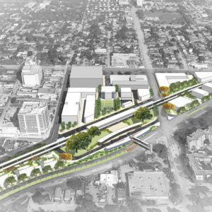
The Underline, formerly the Greenlink, a plan to create a 10-mile linear park along the southern Metrorail route, is gaining attention and support and moving ahead with the help of the University of Miami.

This fall, UM students will be launching an economic impact study tied to The Underline proposal, according to Friends of The Underline.
The proposed renovation of the M-Path for bicycles and pedestrians along US 1, The Underline is being promoted by various county agencies, including the Miami-Dade County parks and transit departments. The idea to use the underutilized land came from Friends of The Underline founder Meg Daly.
The economic impact study comes on the heels of a spring 2014 studio class at the School of Architecture, where students studied the rail route’s existing conditions and created renderings of what could be.
Spearheaded by a powerful coalition of Miami-Dade County’s Department of Economic Resources, University of Miami School of Business Administration and location analytics company Urban4M, UM students will work under the supervision of UM Finance Professor Andrea Heuson to analyze economic growth opportunities along The Underline’s 10 miles from Brickell to Dadeland South stations.
“The economic impact of urban green spaces and bike and walking trails is documented. But The Underline’s impact on Miami’s southern corridor will be transformational. Our students will participate in a change-making initiative for the community,” said Ms. Heuson.
“We’re looking forward to providing actionable recommendations on Underline planning and implementation to achieve the highest possible economic returns,” said Hillit Meidar-Alfi, Urban4M founder and president. “Our software tools are visually driven and can be used by planners, designers and sponsors alike.”
The primary goal of the impact study is to provide implementation and design recommendations to attract “green-space-friendly” commercial development.
It’s no surprise that Underline supporters are following in the footsteps of other metro greenway projects that have met with great success, according to Maria Nardi, the head of planning for Miami-Dade County Parks & Recreation. “Other linear park initiatives like New York City’s High Line and Atlanta’s Beltline commissioned economic studies. To do the best job for our community, we’re following the best practices of other successful projects like these,” Ms. Nardi said.
The current plan is to publish the economic study results in early 2015.
Taking her proposal on the road throughout the year, Ms. Daly said she wants the friends group to be a catalyst for a world-class linear park and trail.
That starts with the ambitious goal of creating a 10-mile trail and linear park, then finding other connections in the community to link into a network of greenways throughout the city, she said.
Click here to read the rest of the article.